 |
| 2013 White River 50-mile endurance run. |
Fast forward to last Saturday and Dave, Greg, Paul (from Portland) and I are lined up a few rows back from the front, mildly shivering, at 6am waiting for things to go. Funny that Dave's blog was the first one I read on White River, and here we are together.
At all the prior races I'd done (besides when I've run with my brother) I hadn't really known anyone in the community. Beginnings were always a bit solitary until I got a few miles in and chatted with whomever I was running with.
But standing on that gravel road on Saturday, it felt really nice to be with a group of people I consider good friends. They knew this was my "big race" and they had been supporting me and pumping me up for the last couple of months. I really appreciate that.
Writing about more than nine and a half hours may be too tedious for most, so I will try and summarize:
- Being able to run with friends and talk about all sorts of stuff makes the miles fly by. It's mostly runnable up the first climb and Dave and I reached Corral Pass in three hours.
 |
| Before Corral Pass, ripped Dave and spider monkey me; Glenn Tachiyama photo. |
 |
| Glenn Tachiyama photo. |
- I ate three pieces of water melon and an orange slice. My stomach, which had been fine, knotted almost immediately.
- Dave kept on after I had to stop for a pee break and I ended up running the descent to Buck Creek with a few different people, and got to enjoy some time with Greg again.
 |
| Crew member Lily taking self portraits while waiting for me at Buck Creek AS (mile 27). She later told me I was "late." |
- In the first half I'd been able to eat around 800 calories, which is about what I would normally eat, but every time I had something it made my stomach tight for 15+ minutes. I had a cold coconut water at Buck Creek that didn't upset my stomach and I only grabbed some jelly beans and a few gels from the bags my family had for me there.
 |
| Arriving at Buck Creek in 4:55, which was about what I expected; Mom photo. |
- Starting up the second climb to Sun Top I can eat a few chews and a gel, but that's it. I get ice water at Fawn Ridge (mile 31.7) and am sort of loosely yoyo-ing with a couple of guys but it's getting hot and we aren't really talking more than a couple of words per mile.
 |
| Just before the Sun Top AS; Glenn Tachiyama photo. |
- As I cross the road leading up to Sun Top I see Dave descending. I give him a whoop and when he comes down the road all I can hear is him yelling, "GIDDY UP!"
- The descent from Sun Top to Skookum is rough; a lot like Mountain Highway on the North Shore but more consistently steep and super dusty from vehicle traffic. My feet started to hurt and I could only pull 8-8:30 miles on the way down.
- At Skookum I congratulate Hardrock Hobbit Hewey as he refills my bottles and hands me a cold sponge to cool my head. Two half-cups of coke, the first I've had all day, and I finally relent and put in my headphones to try and manage the last 6.5 miles of rolling trail.
- I made it, but to be honest I really faded on those miles, reduced to hiking almost every "hill". I got passed by four or five people and while not bonking, I just didn't have much energy.
- A big thank you to Kevin Smythe, who was ultra-generous and didn't pass me in the last 100 yards when I'm sure he could have blown by me.
 |
| Hiking up a Skookum "hill"; Takao Suzuki photo. |
Last year Dave made a time chart for 50-mile trail runs, as it's kind of hard to think about if you're not running them yourself. For people not familiar with trail ultras, it is a good basic "guide":
I had a goal of sub-10, not for any good reason, just because it's where I thought I would finish. 9:30 was probably about the fastest I could see myself going.
I finished in 9:39:55 (63rd out of 286 finishers; 41 DNFs). Dave obliterated his 2012 time by 58 minutes, finishing in 9:10; Paul was only ten minutes back in 9:20 and Greg came in at 10:20 (saying he had a rough second half).
 |
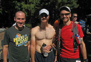
| Dave, Paul, me. |
Awesome course, amazing volunteers (super fast and attentive) and good friends. I also got to meet some fellow PNW runners that I'd previously only known virtually, and know I'll be seeing some familiar faces at Angel's Staircase in two weeks.
I was really inspired by some of the runners that came in later in the day as we were leaving. Lily and I stopped (as well as Dave in his car behind us) and clapped for every runner on the road; they were coming in around 13 hours, with big smiles on their faces and giving us thumbs-up.
Thanks to all the White River organizers.
Thanks to all the White River organizers.
As Dave said, "Giddy up!"


