Monday, August 17, 2015

Mt. Daniel circumnavigation, Alpine Lakes Wilderness

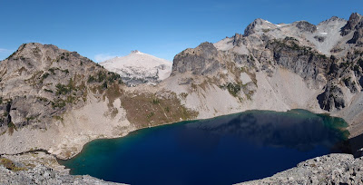
Sir Hikes a Lot invited me on a long-form circumnavigation of Mt. Daniel in the Alpine Lakes Wilderness. He chose a longer and possibly more-scenic route instead of the tight loop, and it's a tour of basically every alpine lake on the mountain proper.

In summer, as opposed to a ski tour, the route is marked by a continuous 10-mile stretch of cross country travel mostly consisting of talus and scree with a few very cool areas of glacially-scoured slabs and a disintegrating glacier descent at the end.

The clockwise loop was approximately 26.5 miles with 9,100' of gain.

Sir Hikes made a little video as well:


The Citadel (with the pass just below right) and Circle Lake outlet above Deep Lake, on the traverse from Peggy's Pond to Circle Lake
Sir Hikes traversing toward Circle Lake, the Citadel above
Smoke blankets the view to the east; with Mt. Stuart
Circle Lake, looking back east toward the approach traverse
Climbing up to Citadel Pass, above Sir Hikes
Hinman, Bears Brest, Summit Chief and Rainier, over Spade Lake; from Citadel Pass
Goats on the descending traverse to Venus Lake
Sir Hikes descending to Venus Lake, with Bears Breast
Venus Lake below Mt. Daniel; pass to the next drainage at center-left
Venus Lake and the south face of Mt. Daniel
Hinman-Daniel col, Hinman, Bears Breast
Short swchack on the way to Hinman-Daniel col; Sir Hikes photo
Rising traverse to the col
Looking back at the pass above Venus Lake, from near Hinman-Daniel col
Glacial retreat lake north of Hinman-Daniel col
Very unstable glacier and moraine terrain
Glacier visible under the debris at center-left; traversing through new slide muck
On the Hinman Lakes bench, with Dip Top Peak
Lower Hinman Lake and Dip Top Peak 
Smoke jumpers' plane; Sir Hikes photo
East Fork Foss River headwaters basin; looking up at the climb to Pea Soup Lake
On the beginning of the slab climb to Pea Soup Lake; Hinman and lakes bench behind
Midway up the slabs; Sir Hikes photo
Dip Top Peak from midway up the slabs; Sir Hikes photo
Sir Hikes styles the slabs, near the top
Mt. Daniel's retreating Lynch Glacier over Pea Soup Lake
Sir Hikes photo
Descending the glacier from Dip Top Gap to Jade Lake
Icy and slushy at the same time, with crevasses opening a bit; Sir Hikes photo
Nearing the bottom of the glacier; Sir Hikes photo
"Thank you" to the couple for taking our picture!
Dip Top Gap above the glacier and Jade Lake
Reaching Marmot Lake and maintained trails back to the car


Sunday, August 9, 2015

Skyscraper-Third Burroughs-Mount Ruth loop, Mount Rainier National Park

Following the Goat Island Mountain-Banshee Peak hike from July, I started looking more at the MRNP map for other loops (have to get full value out of that America the Beautiful pass!). The Skyscraper-Third Burroughs-Mount Ruth loop takes you up three 7,000'+ peaks, passing through forest, parklands, pumice deserts, some talus/scree and ample views of the lower 48's largest glacier (The Emmons). A highly-enjoyable route on Rainier's northeast side!

Luckily, Steve was able to join me and whatever slight chance of rain was in the forecast appeared to keep the crowds away as there were very few people out, besides on the popular trails (Glacier Basin).
We went counterclockwise from the White River campground; 21 miles with 8,000'+ gain
Skyscraper Mountain (7,078') from the Wonderland Trail in Berkeley Park
From the summit of Skyscraper, with building lenticular clouds; Third Burroughs below Steamboat Prow and Ruth on the left of the Inter Glacier
Steamboat Prow, Emmons and Winthrop glaciers, Curtis Ridge, Willis Wall
Goats below Skyscraper Mountain
Steve on the short XC traverse from Skyscraper to the Third Burroughs trail
Steve, with the route from Skyscraper (center)
Summit of Third Burroughs (7,828')
Winthrop Glacier, from the summit of Third Burroughs
Rockfall from upper Curtis Ridge onto the Winthrop
Looking W-NW from Third Burroughs: Russel Glacier with Observation and Echo rocks, Mystic Lake, Old Desolate, Vernal Park and Sluishkin Mountain
Descending from Third Burroughs into Glacier Basin; Little Tahoma, Ruth, Inter Glacier, Steamboat Prow
Climber's trail out of Glacier Basin headed to Ruth, Steamboat and Camp Shurman
White River crossing (upper shin in the middle)
Emmons Glacier
Emmons Glacier
Emmons Glacier
Summit of Mount Ruth (8,690')
Descending Ruth with the Burroughs plateau, Sunrise, Glacier Basin/White River and Goat Island Mountain
One of a group of goats on Mount Ruth