Sunday, November 29, 2015

Thornton Peak attempt, North Cascades National Park

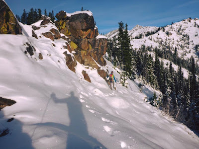
A whole host of issues prevented us from making it all the way out to Thornton Peak (6935') yesterday: compact ice on the steep switchbacks of the road bested Eric's truck (even in 4WD; added four miles roundtrip of road walking), snow was very slow (either deep powder or heavy and unconsolidated, even in snowshoes), then nearing our turn around time we reached a slope I should have switched from snowshoes to crampons to climb up, then would have needed to switch back after the step. Even there, we were still two miles from Thornton Peak and it was already noon.

Not every day can go as planned...with solid consolidated snow, though, the south ridge of Thornton would be great walking! The approach ridge is not as quick and does not offer the views of other off-trail North Cascades approaches I've done (Stetattle, Pyramid, Little Devil, etc).

"Go behind the privy at the trailhead and start going up"
Snowshoes went on at 3700', not far above this
Finally on the ridge proper after ~3m on the forested approach ridge
East(L)-to-south: X Peak, Trappers Peak, Mt. Ross, Davis Peak, Jack Mountain, Crater Mountain, Ruby Mountain, Colonial-Snowfield group, Haystack-Needle-Horseman's Pack, Primus Peak, Austera Peak, The Trapezoid, Big Devil Peak
Thornton's south ridge (Thornton-Damnation divide); south face of Triumph at left
Not the snow conditions we were hoping for/expecting!
Southwest (L) to northwest: Oakes Peak, Electric-Logger buttes, Bacon Peak, Damnation Peak, Mt. Baker, Berdeen Peak, Hagan Mountain group, Mt. Blum, Mineral Mountain
Only about halfway up Thornton's south ridge; Mt. Despair at left and Triumph's summit peeking over
Mt. Blum; east fork Bacon Creek valley in midground
Eric heading back on Thornton's south ridge
Looking south along a flat portion of the ridge


Saturday, November 21, 2015

Miller Peak loop, Teanaway

Miller Peak (6402') sits on the eastern end of the Teanaway, opposite last weekend's trip.

Gavin and I headed up the Miller Peak trail a few hundred yards and then cut straight up to the ridge west of Miller Creek. Our intended route was to traverse that ridge all the way out to County Line ridge and Freedom Peak before traversing back east along County Line to Miller Peak, descending the Miller Peak trail. We traversed a good many bumps, skirted some rocks but eventually cliffed out before Freedom Peak and didn't want to backtrack, drop and traverse to go around, so we headed off toward Miller Peak (which still looked sufficiently far away).

Relevant conditions:
  • We used snowshoes for everything above 5700' and kept them on until probably 4500' on the way down
  • Approximately 10 blowdowns on the Miller Peak trail, a few requiring detours around through brush and a couple duck-unders
  • Starting temperate was 18F; 23F when we finished, though "warm" on the ridges in the sun 


Reaching the ridge proper, above Miller Creek on the west
Traversing the ridge north toward County Line
Traversing to County Line; Gavin's photo
With Rainier, Earl and Stuart
Mt. Stuart and Sherpa Peak

Bobcat tracks
Traversing to County Line; Gavin's photo
On the ridge toward Freedom Peak before turning back; Miller Peak at left
Where we turned around on the ridge to Freedom
Traversing County Line ridge toward Miller Peak
Traversing toward Miller
County Line ridge to Miller Peak
County Line ridge to Miller; Gavin's photo
Miller Peak summit we-fie; Gavin's photo
Thanks Mike and Jared for taking our picture; Miller Peak summit
Descending Miller Peak
Stream fords in 23F air temp...

Monday, November 16, 2015

Yellow Hill-Elbow Peak-Jolly Mountain, Teanaway

The Yellow Hill-Elbow Peak-Jolly Mountain ridge sits at the western edge of the Teanaway. Being a bit further south than the main Teanaway crest and maybe benefiting from an Alpine Lakes rain shadow, it seemed like a good option to get miles in without wading through too much snow.

There are ~five blowdowns in between the TH and Jolly. A dusting of snow covers the majority of the trail from Yellow Hill to point 5850' before Jolly Mountain, and there are a good number of areas with 3-6" of snow; however, route finding is not an issue. The last 1.5 miles to Jolly is consistently 10-12" with windblown drifts of up to 18". Average temperature on the ridge yesterday was ~25F, with a pretty-constant breeze and gusts up to 45+ mph.

Finding a reasonably-fresh wolf track was a huge bonus.


On the ridge between Yellow Hill and Elbow Peak
Heading up Elbow Peak
Climbing up Elbow Peak; fresh snow blowing off the ridge
Elbow Peak summit area, maybe?
Heading toward Jolly Mountain
Heading toward Jolly
Teanaway wolf tracks
Point 5850'+ behind Sir Hikes, approaching Jolly
Deeper snow on Jolly's south slopes
Jolly Mountain summit ridge
Jolly Mountain summit 6443'

Headed home along the ridge; Elbow Peak in the middle, Yellow Hill at left
A few brief views on the way out

Monday, November 2, 2015

Switching gears?

How many more weekends before the waterproof boots and snowshoes need to be dusted off...