Almost more than planning my own trips, I love receiving an invitation for an interesting adventure. The keywords from
Patrick's email (all the way back in April) were easy bait:
point-to-point, 70 miles, Sawtooth crest. Done.
After
Angel's Staircase in 2013 I've been loosely promising myself every summer that I was going to go back and do the
Chelan Summit trail. The logistics with the boat, horrible car shuttle and essentially needing three days when factoring travel in kept me from ever seriously planning to do it. Patrick's invite and determination provided the motivation and his plan to just run the 30 miles of forest service roads along the crest south of the Chelan Summit trail eliminated the car shuttle and pieced together a more complete traverse of the range.
We took the Lady Express boat to Stehekin, followed the Chelan Summit Trail for its entirety and then stayed on top of the ridge on roads 8200 and 8020 until descending to Echo Valley, just northwest of Chelan where the paved road begins, hitching a ride for the highway miles in the back of a pickup that had $300 worth of Costco picnic supplies shifting under us.
Big thanks to Patrick for planning the trip and inviting me along. It was much harder than expected, compounded by me being sick for about four hours (from elevation, I think). We were on a great pace through 27 miles until that happened and it slowed us down over the last ten miles of the Summit Trail until we made up time along the roads.
- Chelan Summit Trail: 300+ blowdowns with nearly half of them in the final miles on the South Navarre portion, which also is very brushy. Plentiful water throughout (except on the climb from Stehekin to Purple Pass). Snow fields, but mostly patches, remain on almost every north-facing pass or basin, though none were an issue and route finding was straightforward.
- Road 8200-8020 Cooper Mountain Road: regular water from creeks and springs until Black Canyon Spring, then no real source down to Echo Valley.
Over the 70 miles we did not see a single person...
 |
| ~70 miles and 16,800' gain |
 |
| On the Lady Express |
 |
| On the Lady Express, looking back at the Chelan Mountains (west side of lake) |
 |
| Docking in Stehekin |
 |
| Stehekin Landing; Patrick's photo |
 |
| Instant vertical relief, climbing up to Purple Pass |
 |
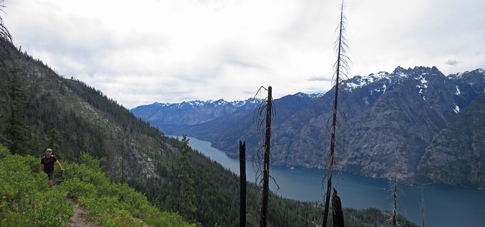
| Pano from Purple Pass |
 |
| One of few (or the only?) continuous on-trail climbs in Washington State that gains over a vertical mile (~5800'+) |
 |
| At Purple Pass |
 |
| Follow the arrow for 31 miles |
 |
| Lake Juanita |
 |
| Chelan-Sawtooth Wilderness Boundary; Patrick's photo |
 |
| Chelan-Sawtooth Wilderness Boundary |
 |
| Big-picture directions |
 |
| South and North Spectacle Butte, Maude, Seven Fingered Jack, Fernow |
 |
| Looking west over the Fish Creek drainage; Railroad Creek is the prominent drainage center-left across Lake Chelan |
 |
| Chelan Summit trail across East Fork Fish Creek, with Oval, Gray, Courtney and Star |
 |
| Chelan Summit trail entering Horseshoe Basin |
 |
| Snow on the climb to the pass separating Fish and Prince Creek drainages, with Courtney Peak |
 |
| Prime larch country |
 |
| Trying to keep dry feet; Patrick's photo |
 |
| Middle Fork Prince Creek drainage with Martin Peak (l), Old Maid Mountain (r); Angels Staircase's west side center-left at back (below the black triangle shadow) |
 |
| Patrick's photo |
 |
| Evening light on Emerald and Cardinal in the northern Chelan Range |
 |
| Final pass; Patrick's photo |
 |
| Climbing up to the last major pass, separating East Fork Prince Creek and Safety Harbor creek; also the junction for South Navarre and Summer Blossom trails |
 |
| Near the pass, looking back across the East and Middle Fork Prince Creek drainages |
 |
| Chelan Summit Trail trailhead at South Navarre |
 |
| 31 miles < 40 miles |
 |
| Patrick sports the space blanket skirt: warm legs while napping and when starting out after said nap |
 |
| As far as running FS roads goes, this one is pretty nice as it stays on the ridge, has good views and tons of flowers |
 |
| Final miles down to Echo Valley, over the foreground ridge; Patrick's photo |
 |
Done... Patrick's photo
|