Today I did the Pilot-Sauk loop counterclockwise and added the short side trip up Johnson Mountain (6721'). An easterly breeze kept morning travel cool, yet a little hazy from the east-side fires (Wolverine Creek probably?).
I was finally able to manage the heat well and move strong all day; I think I was due :) . Thanks to the backpacking party of four near Indian Pass for recognizing me! That was a nice surprise and it was good to chat in the shade for a few minutes.
Relevant trail conditions (all in pretty good shape!):
- Pilot Ridge: 5-10 blowdowns with a few requiring some awkward straddling/climbing over. One creek flowing three miles in from the NF Sauk trail head, then dry until Blue Lake.
- Pacific Crest Trail: some water flowing north of Indian Pass, on the west side of Indian Head Peak.
- North Fork Sauk: streams flowing after the trail turns off the PCT, before the switchbacks. Completely logged out as well. Amazing old growth...
 |
| Footlog across the NF Sauk to the Pilot Ridge trail |
 |
| Climbing up to Pilot Ridge |
 |
| Mount Pugh and White Chuck Mountain |
 |
| For some reason I think these look like Dr. Seuss-style mustaches.. |
 |
| The Monte Cristo group and Sloan Peak, from western Pilot Ridge |
 |
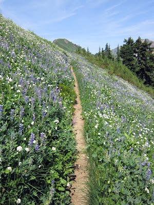
| Pilot Ridge trail through the flowers |
 |
| Pilot Ridge trail toward Johnson Mountain |
 |
| Chipmunk and marmot lookouts |
 |
| North Fork Sloan Creek and the Monte Cristo group |
 |
| Small backpackers on a big ridge; looking back from Johnson Mountain |
 |
| Blue Lake and the high trail over the pass, from midway up Johnson Mountain |
 |
| Glacier Peak and Tenpeak Mountain (far right), from Johnson Mountain summit 6721' |
 |
| Some of the most vibrant paintbrush I've seen |
 |
| Look back west down Pilot Ridge from the pass |
 |
| Both sides of the sign are Wilderness :) |
 |
| Unnamed falls/creek east of Foam Creek (?) |
 |
| Loads of lupine along the PCT |
 |
| Indian Head Peak, from just before White Pass |
 |
| Pretty much shows the whole route along the ridges |
 |
| Back at the car...a darn good day... |


Beautiful as always. Glad the stomach was along for the ride. Any water on the route other than Blue Lake?
ReplyDeleteYeah, one stream about a mile up the climb to Pilot, Blue Lake, streams just north of Indian Pass and west of White Pass, then the big ones down in the NF Sauk. Longest stretch is the 8mi from partway up Pilot until Blue Lake.
DeleteCool, this is the route I'm planning to take my brother and husband on for a backpacking trip in August!
ReplyDeletep.s. Is that red nail polish?
I think it originally was pink...
DeleteThanks for the trail report and the water report. We are planning this hike this coming weekend so your trail report is very helpful.
ReplyDelete